James Thinks
writing is a kind of thinking
I've been using the Garmin eTrex 30 for navigation and to record my rides for four years now. I like it a lot, but I don't think it's the GPS for everyone. Here's my review.
Design and appearance
 To be brutally honest, the eTrex is a chunky lump to put on your handlebars. If it was writing a lonely hearts ad it might describe itself as "rugged". The device sticks up a good 45mm from the handlebars. It's about 100mm long and 55mm wide. It can't even pronounce the word aerodynamic. The colour probably won't match your bike.
The reason it is a bit plus-sized is to fit two AA batteries and a 44x35mm screen. The wider reason for the form-factor is that the eTrex 30 is not aimed at racers, time-trialists or triathletes. It's intended for hikers, sailors and touring cyclists. It is also very popular with audaxers like me.
Around the edge are five small rubbery buttons: Menu, Up, Down, Back and Light/On-Off. These need a firm press which can take a couple of tries in winter when I sometimes wear ski gloves, but I'd prefer this to them being flimsy and getting pressed by accident.
The screen is not touch-sensitive. Instead, on the top is a 4-direction "joystick". It can also be pushed in to select items. Selection in this way is a bit tricky and it is easy to "miss" when trying to push the stick in and ending up pushing it up or down or doing nothing. I find this the same whether I'm wearing gloves or not. However, I'm seldom in a rush when using this button and I only tend to need it two or three times a day. I find that as long as I'm patient and pay attention to where I'm going the button does the job nicely. If my smartphone had an interface like this I'd hate it, but it doesn't bother me on the GPS.
Features and function
The etrex 30 can be used for a lot of other activities like hiking, sailing, etc. It has a load of features I've never used, like a "Man Overboard" button. I can't tell you about those features, as I've only ever used it for cycling.

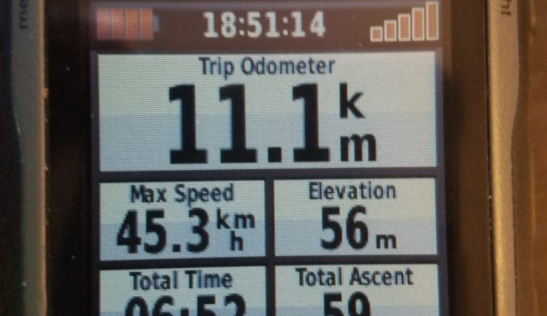
I followed some very thorough etrex 20/30 setup advice and went for a simple system of two screens, one for the map, one for the numbers - time, distance, average speed, battery level, etc. You can choose which fields you want and have them in various layouts. I switch between the two screens using the back button which is quick and easy.
The main thing I use this for is guessing when I might arrive at the next control. If my average speed has dropped but my elevation is high, then I can expect to gain some speed when I descend. Arguably maximum speed is more for entertainment than anything else. Total ascent can be useful when Everesting or chasing AAA points.
I also put two boxes like these at the top of my map screen - Overall Ave. and Distance. You can have four boxes, but it starts to obscure the map a bit. With the help of the up and down buttons on the top left edge of the device (see image above) the map can be zoomed in or out much further than you're likely to want. I use 120m scale for towns and 200/300m for countryside. If you get lost you can also scroll across the map using the joystick, but this is a bit clumsy and slow to update.
You can buy or find additional online maps, but I found those that are built-in to be fine for the UK.
When I've planned a long ride I usually copy a GPX file onto the device so I have something to follow for navigation. You can use the "Follow route" feature which provides a thick pink line as well as some peak and valley icons which don't seem very accurate to me. For simplicity I prefer to simply "Show on map" and select a colour that I find easy to see. I prefer dark blue or red (see below).
I don't get any warnings or beeps if I go off-route, but with an audax routesheet alongside I find navigation pretty easy.

However, this is where you have to be a bit careful on longer rides. There is a track point limit and if you go over it, the end of the route will be cut short. I discovered this halfway through a 300km ride to my alarm. Thankfully I also had a routesheet. I'm not sure exactly what the maximum number of track points is, but it's definitely less than 5000 and more than 4000. I've since learnt several ways to get around this and I always use the "View map" option on the GPS to check my routes are about the right length after I've copied them across. If I use a tool to reduce the number of track points the route often ends up slightly shorter - say 98.6km instead of 100km due to the way the reduced route takes shortcuts across the bends in a road (see image). So I aim to reduce to 4000 track points to get the smoothest track without risking the eTrex cutting off the end. For routes longer than 200km I'd prefer to split the route into several sections.
Like most GPSs the eTrex 30 records the track you travel on for Strava or other ride-recording tools. What I found different to the Edge 500 was that once it's set up the eTrex records all the time - no need to press start. You can save your track to another file or clear the current track, but it will keep recording. If you turn the device off or even change the batteries it will resume recording when you turn it back on. If you've moved while it was off it draws a straight line between the points. What this means is that you need to remember to clear the current track before you start a new ride. That way it doesn't include your car/train/plane journey!
Note: If you're concerned that your total ascent figure is as accurate (and large!) as possible when uploading from an eTrex to Strava, I've made some scripts to fix the way the altimeter data is read.
Other features
- Takes 2xAA batteries which are available anyhere. Rechargeables work fine.
- Good battery life - I've had Eneloops last well over 24 hours.
- Can be powered (but not charged) via USB.
- Mini-USB data connector.
- Can display HR and cadence if attached via ANT.
- Secure bike mount available and lanyard attachment point.
- Reliable - never had a crash or loss of data in four years.
Conclusions
I previously used a Garmin Edge 500. The Edge 500's navigation was very basic, consisting only of a wiggly line, no map and a buzz when you're off course... or the GPS signal has failed. But most annoyingly the Edge 500 has a non-removable Lithium Ion battery that I could never get more than 12 hours out of. While charging on the go is theoretically possible with the right kind of cable, I always found that this reset my route. As I understand it, most of the Edge series (apart from the Edge Touring) is designed for training rides where you might want to record HR, cadence, power, etc, but not ideal for audax/touring.
When all I want is to record my ride and it's less than an hour long, my phone is simpler. But on longer rides I like to conserve my phone's battery in case of emergencies. I haven't tried every GPS out there, but in spite of the user interface quirks already mentioned, I'm very happy with the eTrex 30 for touring and audax.


James Bradbury
I write about whatever is on my mind. I do so mostly to help me think more clearly. If other people find it interesting that's good too. :-)